
Local Plan Main Modifications Consultation
Policy SP7a: Land north of Town End Farm
| Local Plan page number | Policy or paragraph Local Plan | Proposed Change | Justification |
|---|---|---|---|
| N/A |
New Policy SP7a |
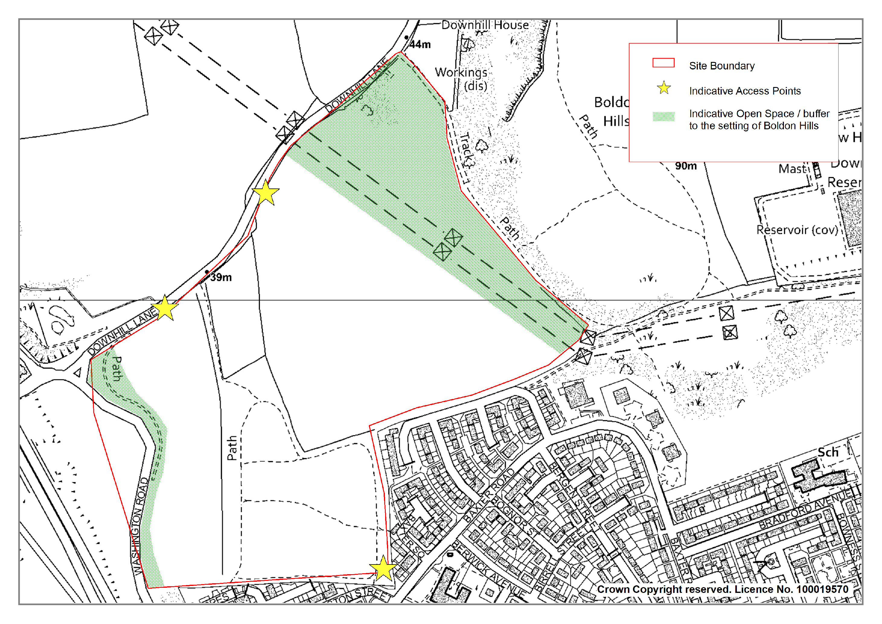
Land north of Town End Farm Land to the north of Town End Farm comprising 22.4 hectares as identified on the Polices Map and Inset Map 9. The site is allocated for approximately 400 dwellings. 1. All development proposals shall be in accordance with an approved masterplan for the whole of the allocated site, agreed between the Major Landowners, that shall be submitted to the Council for its approval as part of the initial application for planning permission. 2. The masterplan shall show the intended overall design and layout of the development, which shall be in broad accordance with Inset Map 9. The Masterplan is to include a phasing and implementation plan which shall identify the phasing of development across the whole of the allocated site to ensure that the development will be carried out in a comprehensive and coordinated manner. 3. All development proposals shall accord with the masterplan as approved, or such variations thereto as may subsequently be approved by the Council. 4. Development proposals shall accord with other relevant policies in the plan including SP25 and SP26 and shall in any event: i. Retain existing mature trees in accordance with Policy 36: Protecting Trees, Woodland and Hedgerows ii. Ensure that landscaping is an integral part of the design paying particular attention to the relationship of the development to the Boldon Downhill area of high landscape value and the need to retain open space in the northeast of the site as identified in Inset Map 9. iii. Be designed to discourage unauthorised access to the Downhill Quarry Local Wildlife Site. iv. Preserve or enhance the settings of the Listed Buildings to the north. v. Enhance the existing bridleway network, and create active travel routes throughout the site and to link with the established settlement at Town End Farm. vi. Provide primary vehicular access from Downhill Lane and secondary vehicular and pedestrian connectivity between the site and Town End Farm. Proposals shall facilitate access to all existing public transport links in close proximity to the site. vii. Ensure that any impacts on the neighbouring area of Sunderland are appropriately mitigated 5. S.106 contributions towards compensatory improvements in the Green Belt will be required where necessary. [added] |
Justified Effective |
| N/A | New Policy SP7a: supporting text and inset map |
In accordance with the Plan’s spatial strategy and housing distribution, the Land to the North of Town End Farm has been identified as a sustainable and suitable location for housing development in South Tyneside and will deliver approximately 400 dwellings. To support this allocation, the Green Belt boundary will be amended through the Local Plan. The boundary for the allocation has been informed by the South Tyneside Green Belt Study (2023), which is an independent assessment of the ‘harm’ of releasing land from the Green Belt to accommodate potential development needs. To ensure the site is brought forward in a co-ordinated manner, any development proposals for the site must be in accordance with an approved masterplan for the whole of the allocated site as identified on the Policies Map. In preparing the masterplan, regard should be had to the key principles identified on Inset Map 9, the South Tyneside Site Framework document (2023) and other relevant policies within this plan Inset Map 9 – Land north of Town End Farm
Applicants must demonstrate that proposals are compliant with Policy SP7a and that the proposal would not jeopardise further development of the wider site allocation. Details of phasing of development across the whole site allocation should be set out in the masterplan. It should demonstrate how the site would be delivered across all phases and ensure that a phased approach would not prejudice the overall delivery of the wider site allocation and supporting infrastructure requirements. The masterplan should also identify well-defined and robust boundaries for the site which will bolster the permanence of the Green Belt. In addition, compensatory improvements to the Green Belt which may include new or enhanced green infrastructure, landscape and visual enhancements, improvements to biodiversity or new or enhanced walking or cycling routes will be secured. Policy SP7a (5) refers to financial contributions towards compensatory improvements in the Green Belt. Potential mitigation and enhancement measures for the Green Belt allocations are outlined in the South Tyneside Green Belt Study (2023) and the South Tyneside Green and Blue Infrastructure (GBI) Strategy (2023) and will be agreed with the Council. Development proposals should seek to address the key consideration set out within criterion 4 of Policy SP7a to minimise wider impacts of the development and to enhance the accessibility and sustainability of the scheme. The site lies within close proximity to the Downhill Old Quarry Local Wildlife Site and Local Geodiversity Site, and Boldon Downhill Area of High Landscape Value as identified on the Policies Map and Policy 39: Areas of High Landscape Value. The masterplan and development proposals should seek to ensure that the design and layout respect the relationship of the site with Boldon Downhill and the wider landscape. To minimise impacts on the landscape and designated site an area of open space should be retained as identified in Inset Map 9. The allocation lies on the administrative boundary of Sunderland City Council and is adjacent to the Town End Farm estate and its supporting social, public transport and road infrastructure. To promote accessibility and connectivity between Sunderland and South Tyneside and access to public transport connections, development proposals should identify vehicular and pedestrian routes into Town End Farm via Boston Road to the south and onto Downhill Lane to the north. Due to the proximity of the site to this area, it anticipated that the proposed development may result in some physical and social infrastructure impacts within the Sunderland City Council area. Where any identified impacts require mitigation, this should be in agreement with Sunderland City Council. [added] |
Justified Effective |
What to consider when making a representation
What are the tests of soundness and legal compliance?
The purpose of the examination is to consider whether the local plan complies with relevant legal requirements for producing local plans, including the duty to cooperate, and meets the national tests of ‘soundness’ for local plans set out in the National Planning Policy Framework (NPPF).
Therefore, representations submitted at this stage must only be made on these grounds and, where relevant, be supported with evidence to demonstrate why these tests have not been met.
Legal compliance
To be legally compliant the plan has to be prepared in accordance with the duty to cooperate and legal and procedural requirements, including the 2011 Localism Act and Town and County Planning (Local Planning) (England) Regulations 2012 (as amended).
Soundness
The inspector conducting the examination in public has to be satisfied that the local plan is ‘sound’; namely that it is:
• Positively prepared – the plan should be prepared based on a strategy which seeks to meet objectively assessed development and infrastructure requirements, including unmet requirements from neighbouring authorities where it is reasonable to do so and consistent with achieving sustainable development.
• Justified – the plan should be the most appropriate strategy, when considered against the reasonable alternatives, based on proportionate evidence.
• Effective – the plan should be deliverable over its period and based on effective joint working on cross-boundary strategic priorities, and
• Consistent with national policy – the plan should enable the delivery of sustainable development in accordance with the policies in the NPPF.